making composit grid - 暋悢偺僨乕僞傪桪愭搙傪偮偗偰廳偹偨僌儕僢僪傪偮偔傞丂
 巊偆僐儅儞僪丂丂grdsample, grdmath 恾壔僗僋儕僾僩晅偒(makecpt,grdimage,grdcontour,psbasemap)
bash 僗僋儕僾僩椺
(恾壔傑偱乯
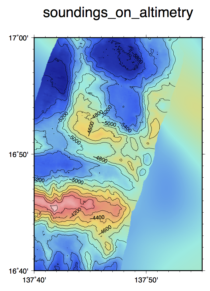
# make composit grid file
# foreground: multibeam bathymetry
# background: altimetry
# parameter setting
region=137:40/137:55/16:40/17 # grid region east/west/south/north
interval=0.04m
# grid interval
tension=0.65
# tension factor
radius=1k
# search radius
xyzfile=area.xyz
# input xyz file
blkfile=area.blk
# block file
grdfile=area.grd
# output grid file
maskfile=area.mask.grd # mask file
maskedfile=area_masked.grd # final masked grid
backgrd=altibathy.grd # background grid file (low resolution)
backgrdsamp=altibathy_resamp.grd # resampled backgorund grid file
compgrdfile=area_composit.grd # composit grid file
#
gmt blockmedian $xyzfile -R$region -I$interval -V > $blkfile
gmt surface $blkfile -R$region -I$interval -T$tension -G$grdfile -fg -V
gmt grdmask $blkfile -R$region -I$interval -NNaN/1/1 -S$radius -G$maskfile -V
grdmath $grdfile $maskfile OR = $maskedfile
gmt grdsample $backgrd -I$interval -R$region -G$backgrdsamp -V
gmt grdmath $maskedfile $backgrdsamp AND = $compgrdfile
# plot
proj=M10
# map projection and scale
ticks=f1ma10m
# boundary tick info
frame=WSne+tsoundings_on_altimetry
# boundary frame info
climit=-6000/-3500/500
# color table min/max/interval
cint=200
# contour interval
cptfile=haxby_area.cpt
# color table
psfile=area_composit.ps
# output postscript file name
gmt makecpt -Chaxby -T$climit -Z > $cptfile
gmt grdimage $compgrdfile -R$region -J$proj -C$cptfile -K -V > $psfile
gmt grdcontour $maskedfile -R$region -J$proj -C$cint -A$aint -L$limit -Wthinner -K -V -O >> $psfile
gmt psbasemap -R$region -J$proj -B$ticks -B$frame -O -V >> $psfile
#
Tips
- 惛搙偺堎側傞暋悢偺僨乕僞僙僢僩傪帩偭偰偄偨応崌丄偡傋偰傪崿偤偰僌儕僢僪壔偡傞偺偱偼側偔丄僨乕僞僙僢僩A偺偁傞応強偱偼A偺抣
傪桪愭丄偲偄偆宍偱暋悢僨乕僞傪廳偹偨僌儕僢僪傪嶌惉偡傞傎偆偑椙偄応崌偑偁傞丅椺偊偽丄應怺婍偱應掕偱偒側偐偭偨奀堟傪嬻敀僨乕僞偺傑傑偵偡傞偺偱偼側
偔丄夝憸搙偼埆偄偑塹惎崅搙寁偐傜摼傜傟偨悇掕悈怺僨乕僞傪擖傟偰抲偒偨偄丄偲偄偭偨応崌偱偁傞丅
- 僗僋儕僾僩椺偼丄慏偱寁偭偨僨乕僞偑側偄応崌偵偼塹惎崅搙寁偵傛傞悇掕悈怺傪擖傟偨偄応崌丅慏偺僨乕僞偺傎偆偼丄偁傜偐偠傔儅僗僋晅偒乮儅僗
僋偼NaN)僌儕僢僪偵偟偰偍偔丅悇掕悈怺偺傎偆偑傕偲傕偲夝憸搙偑掅偄偺偱丄儕僒儞僾儕儞僌偟偰摨偠嵶偐偝偺僨乕僞傪偮偔傞丅嵟屻偵AND寁嶼傪偟偰丄
廳偹崌傢偣傞丅
- 偙偺椺偼2庬椶偺僨乕僞偺廳偹崌傢偣偩偑丄悇掕悈怺亄愄偺應婍偺僨乕僞亄嵟嬤偺寁應僨乕僞丄偲偄偭偨傛偆偵俁偮埲忋偱偁偭偰傕尨棟偼摨偠偱弴斣偵廳偹偰偄偗偽傛偄丅
- 恾壔偡傞嵺偵偼丄怓傕摍怺慄傕崌惉偟偨僌儕僢僪傪巊偭偰昤偄偰傕傛偄偑丄偙偺椺偺傛偆偵惛搙偑挊偟偔堎側傞俀偮傪偁傢偣偰偄傞応崌偵偼丄傓偟傠摍怺慄偼惛搙偺椙偄僨乕僞偱偺傒昤偐偣偰丄暋悢偺僨乕僞偑崿嵼偟偰偄傞偙偲傪柧帵偡傞傎偆偑傛偄丅
- color+contour偱偼側偔堿塭恾偱廳偹崌傢偣傞帪偼丆崌惉偟偨僌儕僢僪偐傜grdgradient偱堿塭僼傽僀儖傪嶌惉偡傞偲尒塰偊偑傛偔側偄丏1乯惛搙偺椙偄僌儕僢僪(NaN偁傝乯偐傜grdgradient偱捠忢捠傝偺堿塭僌儕僢僪傪嶌惉偡傞丆2乯惛搙偺埆偄僌儕僢僪乮慡堟偁傝乯偐傜grdgradient偱1乯偲摨條偵堿塭僌儕僢僪傪嶌惉偡傞丆3乯2偱偮偔偭偨堿塭僌儕僢僪僼傽僀儖傪grdmath偱0.2~0.3偔傜偄抣傪忋忔偣偡傞乮ADD 0.3). 偙偆偡傞偲惛搙偺埆偄晹暘偼敀偭傐偔側傞丏4乯抧宍僨乕僞傕堿塭僨乕僞傕偦傟偧傟傪忋婰僗僋儕僾僩偺傛偆偵grdmath偱墘嶼偟偰廳偹崌傢偣偡傞丏寢壥偲偟偰丆惛搙偺埆偄偲偙傠偼幯偑偐偐偭偨傛偆側姶偠偵側傞丏